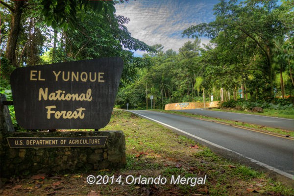
Entrance to El Yunque National Forest
Last Monday was sunny and beautiful. This isn’t to say that the rest of the year isn’t beautiful in Puerto Rico, because it most certainly is, but last Monday was special. The sun was shining bright, there wasn’t a cloud above and the sky was so blue that it made your eyes hurt. Wow!
As many readers of Puerto Rico By GPS already know, I live in Puerto Rico; about 5 miles east of the Luis Muñoz Marín International Airport. That’s about 30 minutes away from El Yunque National Forest. So, as you might imagine, I’ve visited the forest dozens, if not hundreds of times.
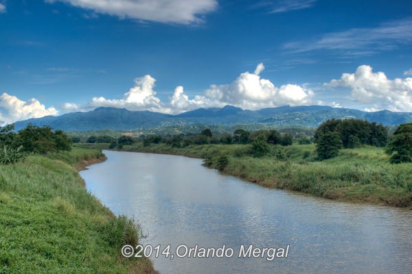
View of El Yunque National Forest from the neighboring town of Carolina. Click on image to see it larger.
And so should you. If you’re planning your next Puerto Rico vacation, El Yunque National Forest should be high on your list of places to visit. It’s like a little slice of heaven just 30 minutes away from the hustle and bustle of the San Juan Metroplex.
Getting to El Yunque National Forest is easy. You can certainly book one of the many El Yunque National Forest tours that are available at hotels and at the piers in Old San Juan. That is, if you’re the kind of person that likes to be shown around. But, if you’re like me, and you like to explore places alone and at your own pace, you can rent a car and combine the forest adventure with other nearby attractions.
La Coca Falls. Click on image to see it larger.
Most of the major car rental companies operate in Puerto Rico and you can get an excellent deal at Priceline. Just click on the blue banner at the upper right corner of this page.
If you opt for the later alternative, el Yunque National Forest is located on Road 191 in the Municipality of Río Grande. In fact, the exact coordinates for the forest entrance are: [18.339389,-65.760178]. Make sure to rent a car equipped with GPS, punch them in and you’ll arrive on a dime.
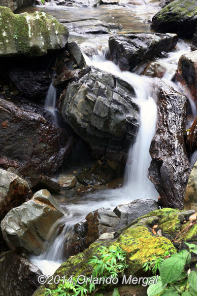
There are waterfalls large and small everywhere. Click on image to see it larger.
Immediately after passing the forest sign you’ll see a side road on your right hand side leading to El Portal Visitor Center. Here you can find general information about the forest, participate in an interpretative tour and occasionally even catch a glimpse of the protected Puerto Rican Parrot. However, while entrance to the forest is free, entrance to the visitor center isn’t. Adults pay a $4 entrance fee, senior citizens over the age of 65 pay $2 and children under the age of 15 enter free. I guess this serves as a small contribution to help sustain the forest conservation efforts.
My wife and I have been at the visitor center before so we continued up road 191. About a mile up the road the first place you arrive at is La Coca Falls. This beautiful waterfall drops 85 feet onto a massive black rock formation that sits at an elevation of 1,476 feet above sea level. And it’s right by the road! You don’t even have to leave your car if you don’t want to. However, with the right wide angle lens and the right camera you can take a picture like mine right from the sidewalk in front of La Coca. There’s an ample parking area about 100 feet further up the road on your left hand side.
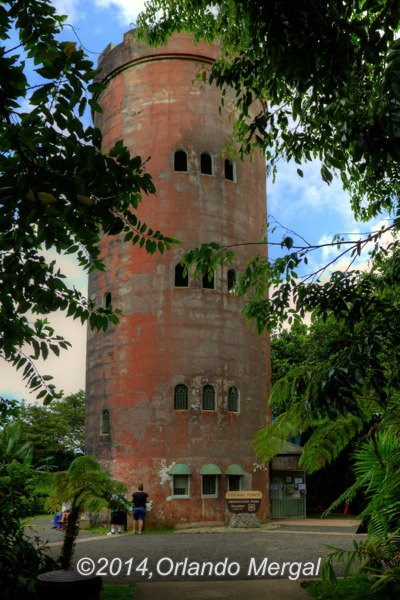
Yokahu Observation Tower. Click on image to see it larger.
Continuing up the road, on your left hand side, you’ll find the Yokahu Observation Tower. On a clear day you can see Puerto Rico’s northeastern coastline from the municipality of Ceiba almost to the town of Río Grande. So if you’re the kind of person that enjoys climbing to high places and looking afar make sure to stop at the Yokahu Observation Tower. The exact coordinates are [18.312408,-65.770293].
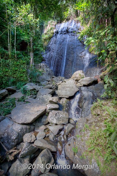
The next attraction on our list is called “Juan Diego Falls” and it’s one of those places that most people miss because there isn’t even a sign. It’s about half a mile up the road on your right hand side. To find it look for two small bridges one right after the other. On the right hand side, right next to the second bridge you’ll see a k‑rail on the shoulder of the road. In case you don’t know what a k‑rail is, it’s one of those concrete dividers that they use on highways to separate ongoing traffic from the oncoming variety.
Juan Diego Falls beautiful and hidden. Click on image to see it larger.
In any case, right next to the k‑rail there’s a small trail that leads into the forest following the river bed. The walk to Juan Diego Falls takes about ten minutes and there are several smaller falls along the way. And just in case you’re wondering, the GPS coordinates for that k‑rail (just in case they remove it in the future) are [18.311819,-65.776988].
Some people bathe under Juan Diego Falls. Others even bring barbeques and spend the day during the hot summer months. But what I really enjoy is making pictures. The place is just magical. Oh, and just in case you’re wondering, there are no large carnivorous animals, poisonous snakes or venomous insects on the Island.
Once you pass Juan Diego Falls the next attraction is a little more distant up road 191. It’s called La Mina Falls and you reach it following “La Mina Trail”. Now, you can take “La Mina Trail” in two directions and from two different points. The first (and hardest) is about 10 minutes up road 191 on your left hand side. You’ll need to walk about 30–40 minutes (depending on your state of health) along a winding forest trail before you actually reach the waterfall.
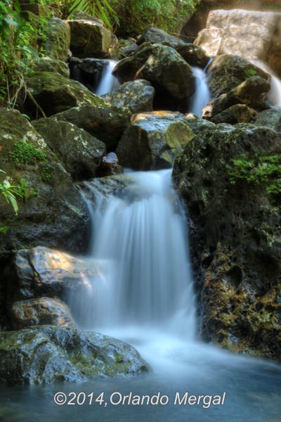
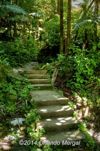
There are dozens of picture opportunities on the way to La Mina. Click on image to see it larger.
However, if you go a little further up the road until you reach a small visitor center on your left, you’ll find a second trail that’s shorter. How much shorter? About 10 minutes shorter. This trail follows alongside the river bed so there are a lot more photographic opportunities. It’s also mainly downhill. But keep in mind that all that downhill walking means you’ll be going mainly uphill on your way back. In any case, the trail is shorter and the way is beautiful. The coordinates to take this second trail are [18.30101,-65.785581].
My wife and I went down this trail last Monday and the whole trek took about two hours. But that wasn’t because of the distance, but because we stopped along the way to make lots of pictures.
Make sure to dress for the occasion. Click on image to see it larger.
Now here are a couple of things to keep in mind. First, wear comfortable shoes. This is certainly not the place to break in that brand new pair of hiking boots. Bring a broken-in pair that’s comfortable and already molded to your feet. Wear light and loose clothing. Although the temperature in the forest is cooler than in the San Juan area the humidity is way higher. More humidity means more sweating, so bring several bottles of water. Finally, sometimes mosquitoes can be a problem. Remember, they breed in water. So when it rains a lot… well, you get the picture. So drop a small can of mosquito repellent in your backpack as well.
Oh, and if you are a diabetic like me, bring along some fruit. Grapes, apples and bananas are great choices. Remember, your medication will constantly try to keep your blood sugar levels at bay. But if you don’t load up on carbohydrates you’ll run out of gas on your way back up. How do I know? Because it happened to me and it’s no fun!
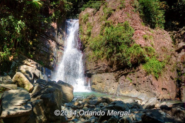
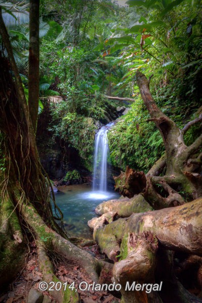
La Mina Falls. Click on image to see it larger.
And, by all means, bring a camera. Even if you’re not a professional photographer there are few places in the world like El Yunque National Forest. So why not capture the experience and make your friends jealous?
Finally, if you decide to explore Puerto Rico on your own there are dozens of articles in Puerto Rico By GPS that will point you in the right direction about driving in Puerto Rico, when to visit Puerto Rico and why and the right kind of GPS unit to bring (or not to bring).
And if you would like to make your visit to El Yunque National Forest a day-long trip check out our posts and pages about nearby Luquillo Beach, Seven Seas Beach and even the Cabezas de San Juan Nature Reserve in the neighboring town of Fajardo. Any one of these places can be the perfect compliment to make your day-long trip to the northeastern tip of Puerto Rico an experience that you’ll cherish for a lifetime.
Enjoy Puerto Rico,
©2014,Orlando Mergal, MA
____________________
Bilingual Content Creator, Blogger, Podcaster,
Author, Photographer and New Media Expert
Tel. 787–750-0000, Mobile 787–306-1590
![]()
![]()