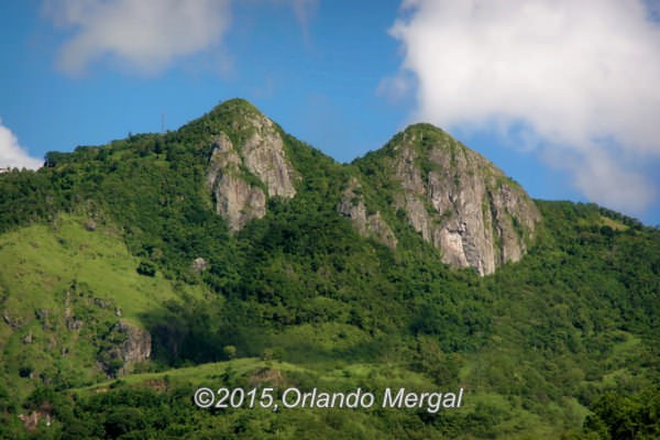
Las Tetas De Cayey
Many readers have commented that Puerto Rico By GPS hardly has any coverage of the southeastern region of the Island. Well, there’s a reason for that. The are three major attractions that all tourists ask about when they arrive in Puerto Rico: the old city, the rainforest and the beaches.
The old city —of course— is Old San Juan, a Spanish colonial city established in 1521 that is the second oldest continuously inhabited town in the Western Hemisphere and a UNESCO World Heritage Site as well. This is the one place in Puerto Rico that almost 100% of our visitors get to see because the Island’s main airport is only a few miles away and all the cruise ships dock at San Juan Bay.
El Yunque National Rainforest is only about 25 miles to the east of the San Juan Metroplex and most tourists buy a day excursion to visit this one-of-a-kind area.
Then there’s the beaches. What can I say about the beaches? Well let’s just say that I wrote a book about Puerto Rico’s beaches that covers 20 of the most gorgeous places in the world. And I only scratched the surface!!!
So why is it that Puerto Rico By GPS doesn’t have much information about the southeastern coast of the Island? Simple! The southeast has stunning vistas and great restaurants, but great beaches is the one thing that it doesn’t have. Most shorelines are rocky and full of riptides, all of which makes them downright dangerous.
This doesn’t mean that you shouldn’t explore the southeast. It just means that if beaches are your thing then you’ll find better options elsewhere on the Island.
But what happens if you are a photographer like me, or if you absolutely, positively love seafood? Then you’re in for a treat because the southeast is peppered with some of the greatest seafood restaurants on the Island and the photo opportunities are stunning.
Last Tuesday I decided to put an end to the lack of coverage about the southeast in Puerto Rico By GPS. So I hopped on my SUV and hit the road with my wife Zoraida.
The best way to explore the southeast is to take road PR-52 in San Juan, drive all the way to Ponce on the south coast and then drive east on PR‑3 along the coastline until you reach the town of Humacao. From there you can connect with PR-30, drive to the town of Caguas and take PR-52 back to San Juan.
This trip was going to be a long one, so we left at around 8:00am and we were back home at around 8:00pm.
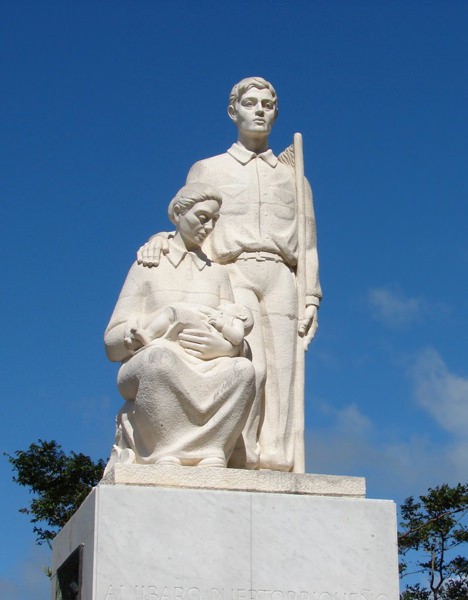
Monumento al Jíbaro. Click on image to see it larger.
Our first stop was at kilometer marker “49.0” at the “Monumento Al Jíbaro Puertorriqueño” (Monument to the Puerto Rican Country Worker) (18.07106,-66.218312). This monument was sculpted by Tomás Batista and unveiled in 1976. It’s also an excellent vantage point to see “Las Tetas de Cayey”, a couple of granite mountain peaks that are actually in the municipality of Salinas. These peaks have an elevation of 2,762 feet above sea level and there name comes from the Spanish colloquial term for “breasts”. I guess you could say that they are the most photographed breasts in Puerto Rico.
From there it would have been road, road and more road until we reached the town of Ponce, but since that was the very first place that I visited when we kicked off Puerto Rico By GPS, and the experience was rather bittersweet (read the article here), we decided to take exit 65 towards Campamento Santiago and take road PR‑1 south towards the municipality of Salinas. From there we took road PR‑3 eastbound along the entire southeastern coast until we reached the town of Humacao.
Click on image to see it larger.
The town of Salinas is famous among the locals for its seafood cuisine. If you are into urban photography (which I am not) you can make excellent images around the town’s main square. In my case I was on a mission to capture seascape images for a project that I am presently involved in for the federal government.
Oh, and if drag racing is your thing, the Salinas Speedway is an excellent place to spend a couple of hours watching the local “gearheads” burn some rubber under the hot Caribbean sun.
From Salinas we continued along PR‑3 to the neighboring town of Guayama. It was almost lunchtime so we stopped at a place called “La Casa de Los Pastelillos” (the house of the turnovers) (17.936356,-66.183156) where —as the name would suggest— you can get huge turnovers filled with almost anything you can imagine, including —of course— all kinds of seafood.
A stretch of coastline in Guayama right behind “La Casa De Los Pastelillos”. Click on image to see it larger.
Right behind the dining area there’s a stretch of coast that I wouldn’t be caught dead in. But it makes for stunning photographs. The shore is rocky, which almost always means lots and lots of sea urchins, and the tide is furious to say the least.
We returned to PR‑3 and went a little further to the east until we reached road PR-7710. This led us to the old Aguirre Sugar Mill. The sugar industry in Puerto Rico all but disappeared during the 60’s and 70’s but you can still see the many buildings that comprised an entire town known as the Aguirre Company Town during the 30’s and 40’s.
Aguirre had its own hospital, commissary, swimming pool, theater, hotel, golf club and post office. But today most of its buildings are closed and have become living examples of urban decay. In my humble opinion this is very shortsighted on behalf of the local government, as the entire area could be converted into a very interesting tourist attraction.
From there we returned to PR‑3 and headed east towards the town of Patillas. We stopped several times along the way to make images of the shoreline, but —once again— none of these areas were suitable for swimming.
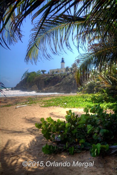
Punta Tuna Lighthouse. Click on image to see it larger.
Eventually we reached the town of Maunabo where we visited, or rather photographed, the “Punta Tuna” Lighthouse (17.988256 ‑65.885203). I had been meaning to add this image to my collection of the Island’s lighthouses. However, when we got there the place was closed. There was a sign on the gate that said that the lighthouse is open to the public Wednesdays thru Sundays. And, of course, I went there on a Tuesday.
I was almost about to leave when I saw a couple men talking by the edge of the road. I asked them if there was a vantage point nearby where I could make some images of the lighthouse. They told me about a small trail to the left of the main gate that leads down to the shore. So we returned to the lighthouse, parked our vehicle and walked down to the shore.
The view was OK but I had the sun in front and to my right; not the ideal position to make a good image. However, I managed to hide behind the vegetation, used it as a frame, and came up with a pretty good image.
On my way out I had an idea: why not find another vantage point west of the lighthouse from which I could shoot the lighthouse from the other side? After trying several of the adjacent streets we ended up at the local fishing village (17.991227,-65.888781). From there I could see a coastline in the distance that seemed to be the perfect place from which to take my shot. There was a group of locals talking by the pier and I asked them how to get there. To my surprise, one of them was a retired gentleman from New Jersey who happened to make the small town of Maunabo his retirement paradise. And, of course, everyone called him “el gringo”.
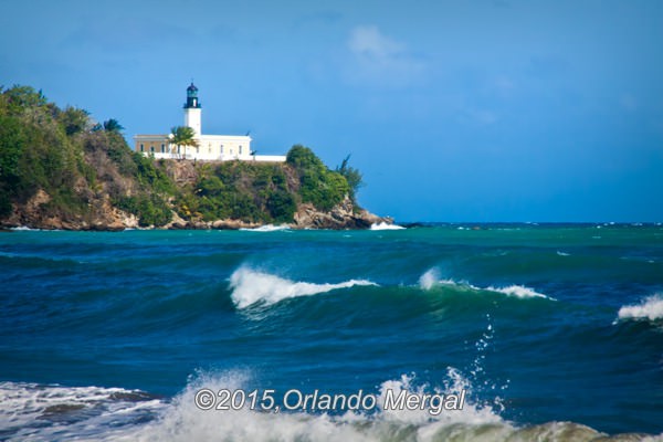
Punta Tuna Lighthouse. Click on image to see it larger.
This man not only told me where to take my shot from, but he actually got in his car, told me to follow him, and took me straight to the spot (17.99099,-65.894553). And, of course, the gorgeous shot that you see below was the one that I took from there.
From Maunabo we took PR-901, connected to PR-53 and eventually PR-191 to get to the south side of El Yunque National Rainforest. I had heard that the other side of “El Yunque” was beautiful, but the fact is that the whole thing was disappointing. The road is closed off at the very entrance (18.265204,-65.801089) and the only thing to see is a small aqueduct that no longer seems to be working. Besides, I met a local man who told me that the area is ridden with thieves who watch as you walk away from your vehicle and steal your valuables, your radio or maybe even your whole car.
So my advise is to save yourself the trouble and pass on the south side of “El Yunque”.
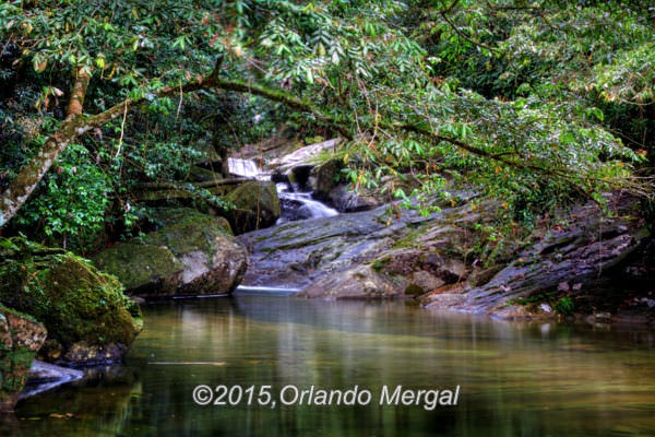
South side of El Yunque Rainforest. Click on image to see it larger.
When we left the forest it was almost 4:30pm so we headed back to the San Juan Metroplex. If you are going to be staying in San Juan, and you decide to visit the south side of “El Yunque” your best bet will be to make a right at PR-31 on your way out (there’s an old metal bridge there), follow it until you reach PR-30 and head west until you connect with PR-52. From there go north until you reach the San Juan Metroplex.
All in all the trip was entertaining, there was plenty of stunning scenery to shoot, and if I had been looking for places to eat I would have had more than enough variety. But now I understand why this area is not as popular as the rest of the Island: it has no beaches. Of course, it has plenty of potential in other areas but local municipalities don’t seem to have the money, or the imagination, to develop that potential. And it’s a sad thing because the area is just as beautiful as the rest of the Island.
Enjoy Puerto Rico,
©2015,Orlando Mergal, MA
____________________
Bilingual Content Creator, Blogger, Podcaster,
Author, Photographer and New Media Expert
Tel. 787–750-0000, Mobile 787–306-1590
![]()
![]()