
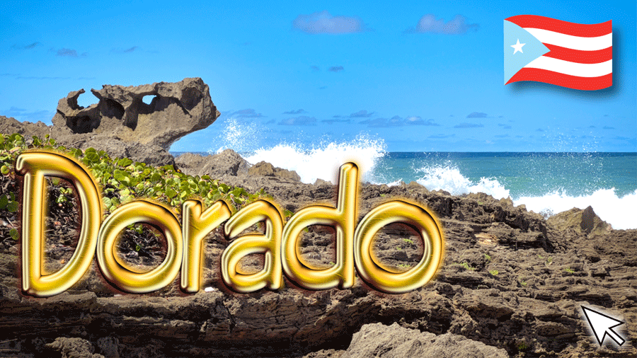
Dorado Atlantic Coast
(click on image to see it larger)
If Dorado weren’t called Dorado, it would need to be called “Lindo”. Why? Because it is! You see, the word “lindo” means “pretty” in Spanish, and that’s one thing that this town definitely is.
Dorado is the 12th smallest municipality in Puerto Rico and the 6th in terms of per capita income. With that comes lots of financial inequality, but that’s a matter for another post.
My wife and I visited the town of Dorado twice. Once on the afternoon of April 5th, on our way back from our visit to Vega Alta, and again on April 18th. Our first visit was one of sheer opportunity. We were driving by and we saw the church open. So we decided to film it, in case it was closed when we returned. As it turns out, the church was actually closed when we returned on April 18th, so it turned out to be a smart decision.
Click on image to watch a short video
There are two ways to get to Dorado from San Juan. You can take Toll Road 22, and see nothing but countryside and buildings, or you can take the “scenic route” and drive along the southern shore of San Juan Bay and the Atlantic Ocean. We took the later.
You’ll know you’re in Dorado territory when you see a giant Seahorse monument on the right-hand side of road 165. These are the exact coordinates: “18.466396, ‑66.210644”.
Some people stop to shoot a couple of selfies, enjoy the view of the Atlantic Ocean coast and breath the fresh salty air. Others, the more adventurous type, even go for a swim. But be advised that this is not the best beach area. There are no facilities whatsoever, the coast has very little sand and is even rocky in some parts, and the surf is menacingly strong. There are much better alternatives and I’ll tell you all about them in a few paragraphs.

A couple of miles down the road you’ll pass a large curve and arrive at the intersection with road 693. I’m sure it had an exit number at some point in time, but the sign was nowhere to be found.
Turn right at the intersection with road 693, drive about a half a mile, go over the bridge and turn right at the first intersection. You’ll immediately find a small parking lot on your right-hand side.
That river that you’ll see immediately east of the parking lot is the “La Plata” River, originally calle “Thoa” by the Taíno natives. In fact, that’s where the municipalities of Toa Alta and Toa Baja got their names.
La Plata is the longest river in Puerto Rico. It flows south to north and goes through the municipalities of Guayama, Cayey, Comerío, Naranjito, Toa Alta, Toa Baja, and Dorado on its way to the Atlantic Ocean.

Julio Barreto Monument
(click on image to see it larger)
When we turned right, immediately before reaching the parking area, I noticed two features that you might be interested in. The first was a statue of “Julio Barreto”, a local crab trapper and the other a “Coquí” standing next to a “Maga” flower. I guess this piece evokes “puertoricanhood” (yes, I just made up that word) since the “Coquí” is a little frog that’s everywhere on the Island and gets its name onomatopoeically. As for the “Maga” flower, it’s considered the Island’s emblematic flower.
And here’s a fun fact, depending on who you ask. Did you know that there are Coquí frogs in the large island of Maui in Hawaii? That’s right, and they’re driving the hawaiians crazy!!!
You see, the Coquí frog is native to Puerto Rican. In fact, its scientific name is Eleutherodactylus Coqui. It lives pretty much everywhere on the Island, but it particularly loves the trees. And you know what else it loves? Rain. You can hear thousands of them after a rainfall with their unmistakeable song: coquí, coquí, coquí…
Well, somehow a couple of those Coquí frogs made their way to the island of Maui. Eventually they also made their way into the wild and, since they have no natural predators over there, they reproduced like crazy.

Puerto Rican Coquí
(click on image to see it larger)
A coupe of yeas ago, I was watching a news piece about this situation and in some areas the problem is so bad that local authorities are exploring ways to exterminate them. I remember a receptionist, at one of those “open air hotels”, that couldn’t hear the person on the other end of the line because the “coquíes” were so loud.
I mean, for us in Puerto Rico it may even seem funny, but the hawaiians aren’t very amused. If you would like to hear what the calling of “coquíes” sounds like hit the player below.
You Can listen to coquí frogs here.
After parking our SUV we walked south along the river bank, under the bridge and arrived at a small park called the “La Plata Recreational Area”. There are benches for people watching, trees galore and one of those huge chairs, to take your selfie, that seem to be popping up everywhere on the Island.

La Plata Recreation Area
(click on image to see it larger)
There’s also a two storey gazebo-shaped structure that had seen better days until it ran into the fury of hurricane María back in 2017.
One thing I should mention is that there seems to be construction going on everywhere in the town of Dorado. In fact, we were told that one of the places up for renewal is that gazebo-shaped structure. As it stands now, the second level is closed to the public.
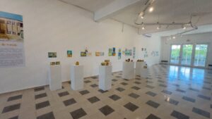
Right next to the park there’s a small museum called La Plata Exhibition Hall, or “Sala de Exposiciones La Plata”. It’s an itinerating museum mainly dedicated to local and Island artists. The day we visited there was an exhibit by children from a local school.
-

- La Plata Exhibition Hall
(click on image to see it larger)

-
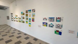
- La Plata Exhibition Hall
(click on image to see it larger)

-
- La Plata Exhibition Hall
(click on image to see it larger)

-
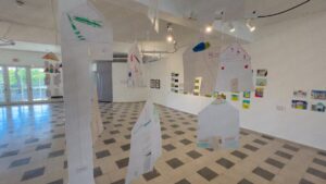
- La Plata Exhibition Hall
(click on image to see it larger)

Now, here’s a fun fact about Dorado. It’s a town on a hill. So the easiest was to explore it is to park your car, explore the area around it, then move you car and explore again. Otherwise, you’ll end up exhausted and with your car across town.
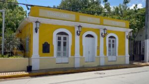
So that’s what we did. We walked a little further up Méndez Vigo street to the Casa Del Rey, a neoclassical structure built in 1823 to house Spanish personnel. The building was restored by the Puerto Rico Institute of Culture back in 1978 and a year later it was included in the U.S. National Register of Historic Places.
Contrary to our experience at La Plata Exhibition Hall, which was quite delightful, our visit to La Casa del Rey was rather underwhelming. In fact, most of what I learned about La Casa Del Rey I got from the Internet.

Casa del Rey Museum | Dorado, 23 Square Miles Of Beauty And Adventure | Puerto Rico By GPS
As we walked in the door we were told that we couldn’t shoot any video. What’s more, we could make any photographs either. So the few pictures in this post are from the facade and whatever I could “sneak out”.
I also felt like it doesn’t follow a common theme. It’s more like a hodgepodge of all things “Dorado”.

Juan Boria Arts Center
(click on image to see it larger)
Across the street you have the Juan Boria Arts Center which is presently closed for restorations. Juan Boria Romero was born on February 17, 1906, in Dorado and gained international fame as a bomba and plena performer and composer. Bomba and plena are —of course— Puerto Rican folkloric rhythms that have a great African influence.
It was time to move our vehicle, so I walked down the hill, drove up, picked up my wife and parked by the Saint Anthony Of Padua Parish. We had already visited the parish back on April 5th.
Saint Anthony Of Padua Parish is a small temple when compared to others on the Island. Construction started in 1842 and six years later the “doradeños” celebrated their first mass in their new temple.

Saint Anthony Of Padua Parish
(click on image to see it larger)
On the outside the building is rater boxy, with three small bells and a simple cross in the center. On the inside it’s a different story, with arched doors and windows and beautiful wood decorations.
There was another thing about this temple that caught my attention. We visited on a bright sunny day. Yet, the temperature inside the parish wasn’t hot, and there wasn’t any air conditioning. The tall ceilings combined with multiple ceiling fans more than did the trick.
Like my friend Fernando Abruña always says: you don’t always need air conditioning. High ceilings, large windows and doors, and a little cross ventilation is often enough.
As we left the Catholic church we went for a walk around the main square. Like most other towns in Puerto Rico, you have a main square with the Catholic Church on the east side and City Hall somewhere on the west end. This arrangement was inherited from Spain, who in turn inherited it from the Romans.

Monument to the Races
(click on image to see it larger)
There’s a monument in the middle of the square honoring the three races that gave way to modern day Puerto Rico. Those were: white Europeans, black Africans and Taínos. I guess you could say that those were the main contributors, because modern day Puerto Rico has become more of a melting pot of multiple cultures and nationalities.
On the southwest corner of the square you have City Hall, which extends across the street to a second building. There’s also a statue of general Santiago Méndez Vigo, the Puerto Rican governor who signed the proclamation creating the town of “San Antonio De Dorado” back in 1842.
I normally don’t mention commercial ventures in my posts, because it erodes my credibility, but in this case it has to do with something that my wife and I enjoyed. Right next to the Santiago Méndez Vigo statue there’s a small cafeteria where you can enjoy the famous “alcapurrias bisexuales”.

Bisexual Alcapurrias
(click on image to see it larger)
So what are those, you might ask? Well, alcapurrias are a local delicacy made of “yautía” (taro root), green bananas and ground beef. Of course, every cook has his/her secret seasoning, but they basically contain Puerto Rican “sofrito”, salt, pepper, coriander and annatto.
First you ground the taro root and green bananas into what’s called “masa” that’s basically seasoned with salt. Then you cook the meat with “sofrito, salt, pepper, coriander and annatto.
Finally you spread some masa into a circle on a banana leaf, put a string of ground meat through the center and roll it into cylindrical form. Finally you fry the whole thing and float to culinary heaven.
So what’s so special about the “alcapurrias bisexuales”? Well, for starters they’re about a foot long. Regular alcapurrias are more like 4 inches. Second, they’re juicy and made as you wait. There’s no sitting under an infrared bulb here.
All in all, it’s “alcapurria nirvana”.
And the name? Well, that’s a gimmick to catch the public’s attention.
After enjoying a couple of these foot-long miracles we walked over to a smaller plaza called “La Plaza de los Doradeños Ilustres, or “The Plaza of the Illustrious Doradeños”, in the King’s English, that has always reminded me of a similar one that we visited in the small town of “Palos de la Frontera”, in the province of Huelva, in Spain.

Plaza of the Illustrious Doradeños
(click on image to see it larger)
It’s a nice little plaza with plenty of benches for people watching and —you guessed it— busts of illustrious “doradeños”.
We had three places left to visit (more like two, because one was closed). When we visited the church, on April 5th, we were told not to miss the “Santuario del Cristo” that’s a little further up Méndez Vigo street, turning right on Paseo Del Cristo street. We were also told that it only opened on Thursdays.
Well, guess what? April 18th was a Thursday and the “Santuario” was closed. So we continued on to Balneario Manuel “Nolo” Morales.
Dorado is a coastal town and it’s also a beach town. And, in case you’re wondering, there’s a difference. Some towns are next to the ocean but they’re hardly beach towns, because their coast is rocky, dangerous or downright dirty and polluted.
That’s not the case in Dorado. However, like in the case of Río Grande (that we covered in a previous post), most of Dorado’s beaches are fenced out by private concerns leaving only the “balneario” for the townspeople to enjoy.
By now you must have figured out that the word “balneario” means public or government-run beach. It also means that you get lifeguards, buoys, signage, showers, restrooms and parking. Best of all everything is free except for the parking. But even that is a nominal fee.

Balneario Manuel “Nolo” Morales (eastern side)
(click on image to see it larger)
Balneario Manuel “Nolo” Morales is actually one large beach divided by a breakwater. I cover this beach in great detail in my book Puerto Rico Beach By Beach so I won’t go into every little detail, but it’s the only place where everyday “doradeños” can go for a dip in their entire municipality.

Balneario Manuel “Nolo” Morales (western side)
(click on image to see it larger)
The eastern portion has lower surf and is suitable for parties with children. The western portion has higher surf and is showing the signs of erosion caused by climate change and rising sea levels.
There was one place left to visit and it was a little after 1:00 o’clock. It’s called “El Ojo del Buey”, in English “The Ox’s Eye”, and it’s a rock formation right next to the delta of the La Plata River.

The Ox’s Eye (El Ojo Del Buey)
(click on image to see it larger)
There’s only one way to get there. You have to drive to the end of a road and walk about half mile along the Atlantic shoreline. Some parts of the trek are along a sandy trail with dense vegetation and others are over rocky terrain. But all of them are under the blistering Caribbean sun.
A wide brim hat, light reflective clothing, hiking shoes, plenty of water and sunblock are certainly in order.
At the end you’ll find a rock formation that resembles the skull of an ox, complete with eye sockets, snout and brain cavity.
It’s quite a sight against the backdrop of the wild Atlantic ocean. And if you’re a landscape photographer like me you simply won’t resist the urge to shoot it. It’s the image I used for the thumbnail of my video.

La Plata River Delta
(click on image to see it larger)
Other attractions in the area are the La Plata delta and several coves along the way. However, be advised that none of this area is for bathing. In fact, as you park your car, there’s a large sign next to the gate warning you about the dangers of this place.
Of course, that same half mile that you walk to “El Ojo Del Buy” is the one you’ll have to walk back on the way to your car.
And let’s leave something crystal clear here. I’m not saying that anything in this area is intrinsically dangerous, because it’s not. But be advised that you’ll be in rugged terrain and under extreme solar radiation. So prepare accordingly.
So how do you get back to San Juan? Well, here’s the easy way. Copy the coordinates for the town square from the map below and put them in your GPS. That will get you out of the Ojo del Buey are and back to civilization. From there, follow road 693 going east until you reach the intersection with road 165. Turn left and follow road 165 until you reach exit 7B going towards Toll Road 22. Follow Toll Road 22 until you reach the Minillas Tunnel in San Juan.
And talking about San Juan, if you’re planning to visit the Old City, save yourself the hassle of traditional city tours. They’re expensive and you’ll be herded along with people that won’t necessarily share your interests.
Instead, order The Old San Juan Walking Tour. It’s packed with useful information about all the main attractions, as well as every GPS coordinate and two hours of exclusive online video. That way you’ll be able to —visit before you visit— and hit the ground running when you arrive in the Old City.
See you next time!
©2024,Orlando Mergal, MA
____________________
Bilingual Content Creator, Blogger, Podcaster,
Author, Photographer and New Media Expert
Tel. 787–750-0000, Mobile 787–306-1590
![]()
![]()